The winter plows bring springs of potholes that litter roads like Christmas tree pine needles. When weather temperatures drop, roadways expand and contract allowing water to seep into the asphalt and create gaps just waiting to be pulled up. Potholes don’t happen right away, usually trouble brews beneath the surface long before a hole forms.
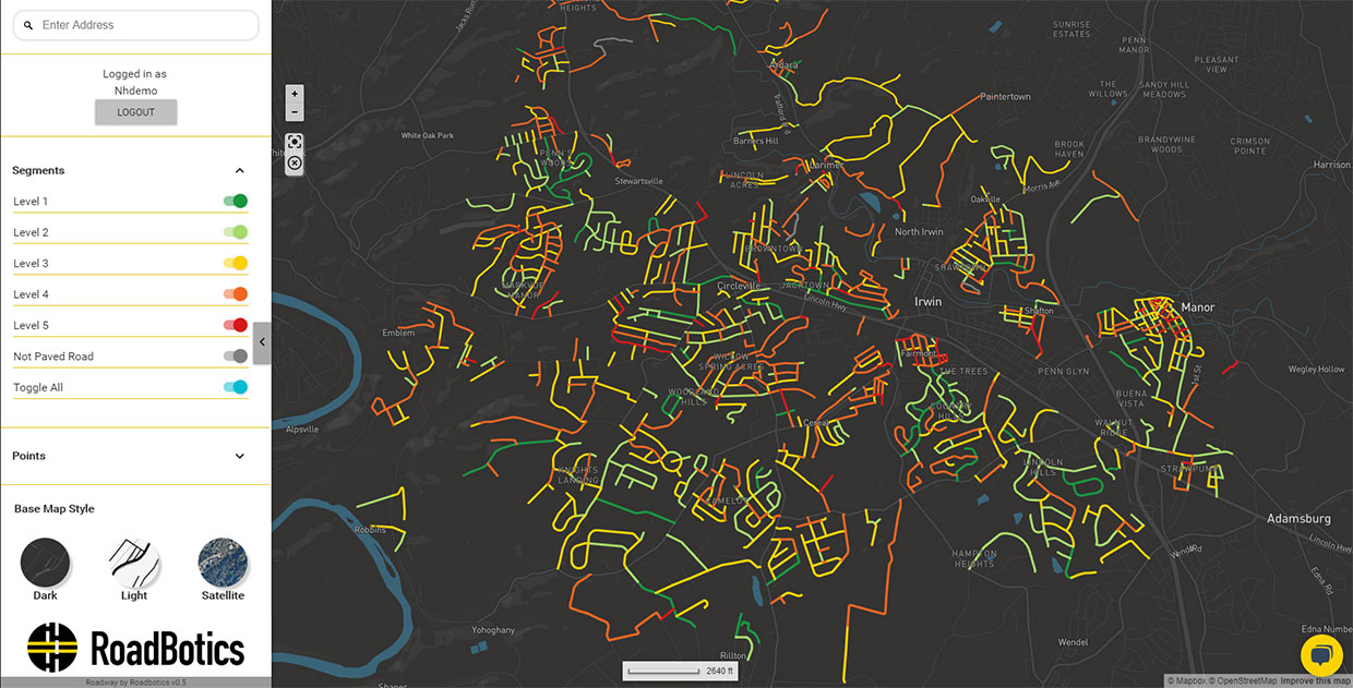
RoadBotics is a company that utilizes state-of-the-art computer vision techniques to aid local governments in taking better care of their roadways. The company developed machine learning algorithms that process images of roads collected through smartphones. The software then takes those images to fabricate a thorough online map of road conditions. These roadmaps provide officials with specific areas to focus their maintenance and repairs.
CTO of RoadBotics Benjamin Schmidt says, “There are things you can do 5 or even 10 years before that happens to push the life span of a road.”
Since its launch in 2016, more than 90 cities, towns, and counties have used RoadBotics technology. Soon, Detroit will join the ranks as the latest city to utilize the technology to inspect its 2,600 mi.
Roads transformed the way we travel, but they come at a hefty expense. Not only are they costly to build, but they are even more exorbitant to maintain. Asphalt takes a beating from weather and cars, breaking down over time. The cracks that form in the blacktop provide avenues for water, salt, and fuel to seep into the road and damage them from beneath.
City officials will send inspectors out to various roads looking for damage, but each of them will have their own opinions on what needs to be repaired. “People get tired, or if you have multiple people assessing big road networks, they may not agree on conditions. We solve a lot of those problems with objective, quantitative data.”
RoadBotics, who offer road assessment as a service, will dispatch vehicles equipped with dashboard-mounted smartphones that drive every mile of the city’s network. The videos and GPS locations are uploaded to a cloud server where it is analyzed pixel-by-pixel by RoadBotics artificial intelligence (AI) algorithm. The company says its “AI can identity every useful aspect of the road surface as well as a human can, from giant potholes to more nuanced factors like bumps, depressions, and cracks.”
The automated assessment creates a map of the road network in addition to an overlay that shows every 3 m stretches of road on a color-coded scale, with one/green being superb and five/red meaning in need of repair. RoadBotics has the potential to save both time and money regarding roadways. However, Schmidt says that the company is looking toward the future, gearing their AI technology to condition other important transportation sidekicks such as streetlights, signage, foliage overgrowth, as well as power lines.

[Image Source: RoadBotics]


