As we closed out November the project team had completed 18 survey lines and 4 tie lines from a total of 9 flights, producing over 16,000 line km of data. The IcePod and team have been a working hard! The closing email for the month of November included these beautiful LiDAR images.
What is LiDAR?
LiDar (Light Detection and Ranging) is a remote sensing technique that uses light to develop an image of the surface of the Earth, and is an important part of our geophysical suite of measurements in ROSETTA. In the IcePod the instrument is located on the pod bottom behind a protected window. In flight, when the pod is lowered to collect data, the window cover slides open and a series of light pulses are sent to illuminate the area below. The time is then measured for the reflected light to return. Because we know the speed of light. and that speed is a constant (0.3 meters per nanosecond…or a very fast 186,000 miles per second!), we can use light to calculate distance with a high degree of accuracy. The equation is simple:
Distance = (speed of light X time of flight)/2 in order to account for the distance down and back from the aircraft. The result is the ability to create these 3 dimensional images of the land surface.
Enjoy these wonderful LiDAR images collected by the project team!
The first image is from a standard pass over McMurdo Base in order to calibrate and confirm that the LiDAR system is working accurately. You can clearly see every building, fuel tank, road/pathway and the very systematic way that the base is laid out. The scale bar showing meters of elevation (or height) listed with elevation noted by ‘Ellipsoidal Height’ in meters, not a unit we see every day.
What is ellipsoid height?
We describe the Earth’s shape as an ellipsoid, rather than round or spherical, as the radius at the polar regions is slightly shorter than the radius at the equator. In reality the Earth’s surface is not smooth like an ellipsoid, instead we have mountains, deep valleys, ocean trenches and other surface features with elevation. However, GPS receivers used to locate placement follow a map of sea level using a reference ellipsoid to calculate elevation. To view these images the best approach might be to look at them as relative measures, for example the image of McMurdo shows a 185 m elevation difference between the the surface at 166°42’E and the surface at 166°39’E.
Located close to McMurdo on the Ross Ice Shelf is a small island ~28 km or 15 miles long called White Island. Protruding up through the ice shelf it is named for its covering of snow, and is a sister to Black Island, named, not surprisingly for its lack of snow cover. Both were discovered on the same expedition in the early 1900s. Using the scale for this image you will see the elevation contours for the island peaking at 40 m Ellipsoid Elevation, approximately 80 m higher than the ice at the ice shelf.
The third image is of crevassing near Crary Ice Rise.
What is an ice rise?
An ice rise is a region of increase in elevation in the relatively flat expanse of the ice shelf caused by floating ice in the shelf physically ‘grounding’ or touching the seafloor below. It differs from an island as the land in an island sits above sea levels. Here the ice is touching land that is still below sea level; it is a section of sea floor raised so that it causes the flowing ice in the deep ice shelf to hit it and drag. This tension of the ice dragging over the contact area, combined with the faster flowing ice around the edges, causes the ice to crevasse as seen in the image.
Our fourth image is of seals lying on the ice. The Weddell seal is well represented in the area of McMurdo, although they are also found distributed around the circumpolar Antarctica. Weddells are well studied by the science community, as they are very accessible, abundant in numbers, and are easily approached by humans. Perhaps they have been imaged in LiDAR previously, but we are happy to have captured them resting on the ice! To provide some context we have included a video of a Weddell seal collected by our project GPS specialist, Sarah Starke.
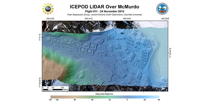
McMurdo Base, Antarctica imaged with LiDAR. (Credit: processed by S. Starke)
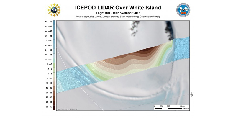
White Island in the Ross Ice Shelf of McMurdo. (Credit: S. Starke)
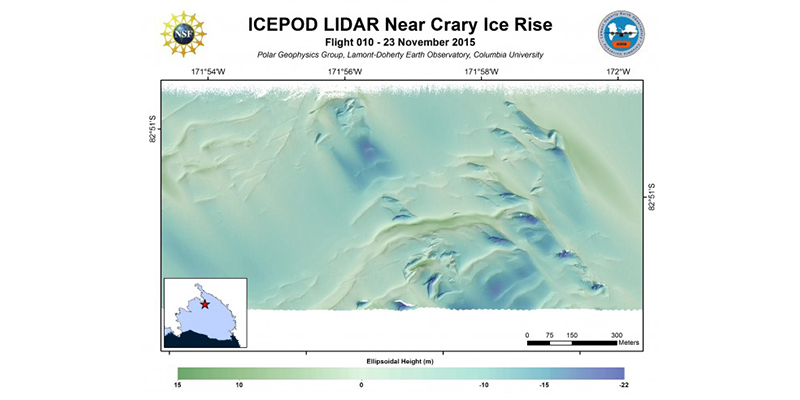
Crary Ice Rise, Ross Ice Shelf, Antarctica. (Credit: processed by S. Starke)
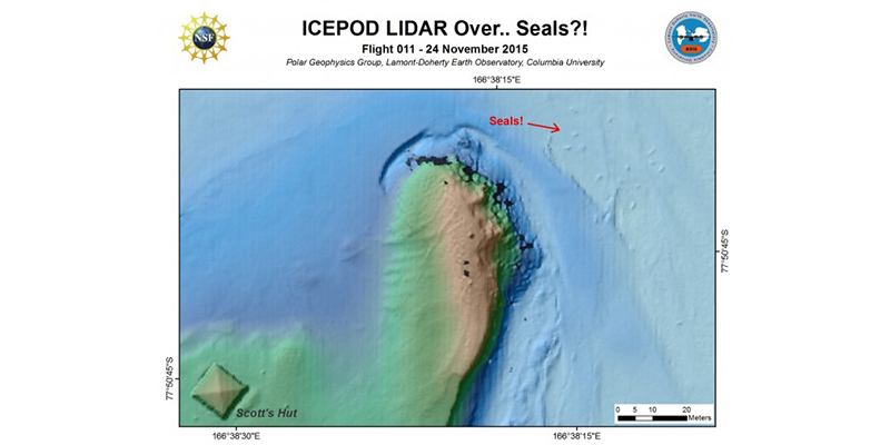
Yes those are seals! Weddell seals lying on the ice and imaged by the LiDAR. (Credit: Processed by S. Starke)